From: http://canoe.freeshell.org/hbl_johnday_tumwater.shtml
Published in September 1999; minor changes indicated by [yyyy-mm-dd]
Embedded pictures are 30
- 75 KByte JPG files -- many thanks to Chris Luneski for
digitizing !
Completing the John Day River
Horst Lueck, mid July 1999
Having done all of the documented stretches of the John Day River (author on Clarno in IK and in raft ), I was wondering what the final section from Cottonwood Bridge to the Columbia River might be like. Of course, reading Arthur Campbell's and John Garren's books "John Day River" and "Oregon River Tours", respectively I learned early on that this part of the John Day (J.D.) is not runnable because of the Tumwater Falls at river mile 10. So what ? -- there are many excellent rivers on which you portage around some falls, dams or levees! Consulting the relevant topo maps (see Appendix) didn't reveal an answer either - there are no falls or rapids mentioned on the entire stretch, only some "Narrows" are shown around RM 10. This lack of information leaves you wondering which other surprises are waiting for you on this section.
Starting from Rufus (I84, exit 109) and checking out potential take-out spots I decided to top off the whole journey by crossing the Columbia River and getting locked through the John Day Dam. This is one of the largest 'vertical drops' in the northwest a kayaker can enjoy and still emerge safely in one piece. I told Jim, the shuttle guy from Rufus, to move my car to the Giles French Park boat ramp so I could take out in Rufus downtown (well, almost) and have dinner there at Frosty's Cafe.
General
I did the float relatively late in season at a flow of only 700 cfs
in an inflatable kayak (Lynx I). The river miles (RM) I am referring to
are based on topo maps compiled or revised in the 1960 to 70s. For fractions
of a mile I am using the following notation: when floating downriver, let's
say half a mile past RM 20 I would be at RM 19.5 . This may sound trivial,
but Arthur Campbell uses a different system -- so be aware of this when
reading his book! Listing drift times doesn't seem appropriate since the
velocity controlling factor were the up-river winds which I experienced
stronger than on any other stretch of the J.D.; one day they started at
7 am, the next day there were none at all.
The stretch between Cottonwood Bridge and the Columbia River can be divided into four sections:
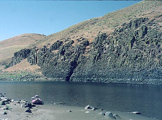
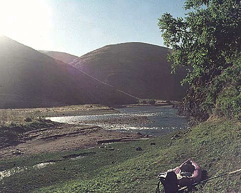
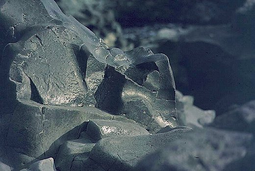
RM 39.7 to 17. Cottonwood Bridge at RM 39.7 is the put-in. You are drifting through relatively open dessert canyons, occasionally passing basalt cliffs , a few ranches, stretches with Jeep trail access alternate with stretches that have no road access at all. This section is comparable to the last 5 to 10 miles of the Clarno-Cottonwood stretch. At low water level none of the few rapids exceed class I and even at significantly higher levels they should be straightforward. Respecting the few fences and 'No Trespassing' signs still leaves you with plenty opportunities to camp . At RM 20.7 you are crossing the McDonald ford of the Barlow cutoff of the Oregon Trail. River left, an Oregon Trail monument one quarter of a mile up the dirt road can be visited, but remember staying on the public road since the owner of the surrounding ranch had fishermen arrested for crossing the line.
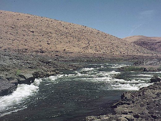
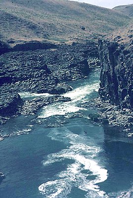
RM 17 - 10.2 .The river picks up speed and at RM 17, but more frequently past RM 15 numerous boulder gardens provide a welcome change of pace. At low water levels in a small craft those boulder gardens don't exceed class I+ , but potential hydraulics at higher water levels and narrow passages may make maneuvering more challenging in a larger craft. Get your camera ready for the otter family at RM 15.2 ! At RM 10.9 the river makes a 90-degree turn from north to west, continuing west for 0.5 miles before it turns northwest. This turn announces the upcoming Narrows.
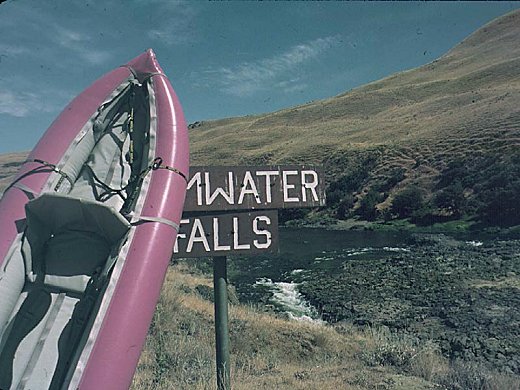
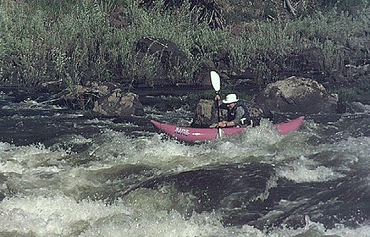
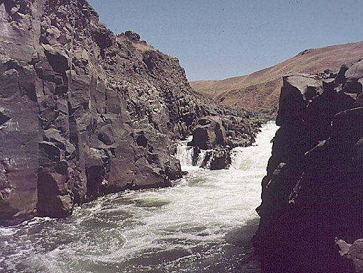
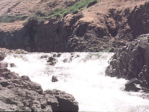
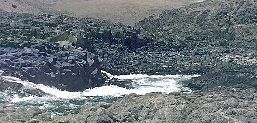
RM 10.2 - 9.8 . The Narrows, starting with the Tumwater Falls. To describe the Narrows, the closest that comes to my mind is somewhat comparable to Niagara of the North Santiam River, only that it extends over 0.3 miles. A continuos cliff river right, a black basalt island in the middle and an intermittent cliff river left, in addition to the obvious noise of the falls, provide a clear warning. Two thirds of the water flows to the right of the island and forms the Tumwater Falls . I scouted river left in hope of finding a route to line the boat along the more open part of the Narrows. I ran the class III rapids left of the island and eddied out onto the island from where I got a close and spectacular view at all the falls around me. At higher water level this is not recommended since you may find yourself trapped on the island. Instead, I recommend to stop early enough river right and scout from there using the easy trail above the cliff. Below the Tumwater Falls you will see half a dozen, 5 foot drops (class IV-V) deep down in the Narrows. If you decide to portage all the way use that trail river right. If you are a solid class V boater and consider running some of the rapids below the Tumwater Falls walk back to your boat, ferry across river left and inspect the rapids also from the left side. At low water level all falls are cascading falls, no extreme drops, no headwalls or undercuts (at least as far I could tell). The second half of the Narrows is popular with fishermen fishing for small mouth bass mainly from the left rim. I ended up portaging most of the Narrows and found a secluded camp spot towards the end, but still inside the Narrows -- a small patch of sand surrounded by marvelous black basalt cliffs, your feet dangling in the water while fishing ... what can be more rewarding after a hard day of scouting and portaging.
Warning - the description above is based on a very low water level of 700 cfs -- at higher water levels the situation may be totally different. Feel free to contact the author via canoe@freeshell.org if you need further information regarding this stretch. (However, author is not an expert on other stretches of the John Day -- for those consult books, maps and links listed in the 'Resources and References' section.)
RM 9.8 - 0 is part of Lake Umatilla. You have to share this section with the occasional motorboat and thousands of carp, some of which forcefully bounce against your boat. The 'river' gets wider and the landscape turns gradually into what you are familiar with from the Columbia River. If you feel like socializing with other boaters you can camp at Albert Philippi Park, RM 3.7 , otherwise you will find more private camp sites on both shores.
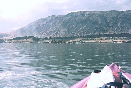
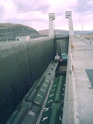
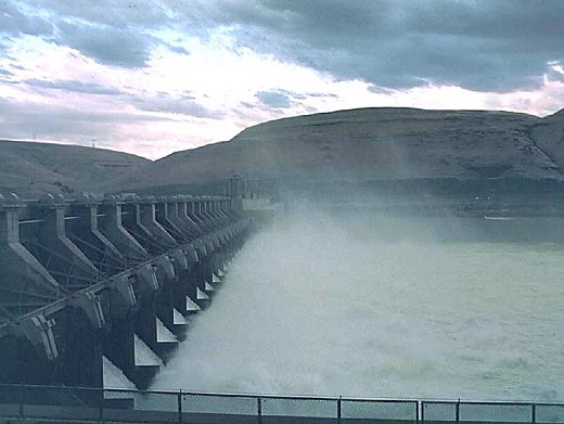
Columbia River RM 118 - 114 . I reached the mouth of the J.D. on a sunny afternoon, finding the Columbia River as calm as a lake. Timing the first barge that went by (ca. 15 mi/h) I made a plan about how to cross safely without getting into a hopeless race with one of the 'big guys' (it takes a loaded barge about one mile to stop). After 50 minutes I reached the northern end of the lock and tied up my boat at the river right entrance of the lock. Hiking across half of the concrete structure and passing through several "Authorized Personal Only" gates I tried to find a human being to present my request of getting locked through (there should be a phone or intercom at water level, but I couldn't find it). During this excursion I got a chance of looking down the empty lock chamber -- although the maximum lift is listed with only 113 feet it seemed to me like looking down a well all the way to the center of the earth (photo after the barge has moved in). Finally I found the lock operator who told me that a barge going upstream was announced via radio and it would take one hour before I could enter the lock and an additional 20 minutes before the dam would spit me out at the bottom. However, by that time the spillways left of the lock exit would have been opened to let the young salmon through. This would shift about 150 000 cfs of the 250 000 cfs average flow from the turbine section river left towards the exit of the lock. While watching the barge slowly approaching the dam a storm moved in. Within half an hour a beautiful sky turned into an ugly gray brew and the winds so typical for the Columbia Gorge picked up. This combination creates a nasty situation; the water pushing downstream and strong winds gusting upstream generate extremely short and choppy waves. In addition to the waves, the opposing directions of wind and current create an ideal condition for capsizing. After consulting with the lock operator I decided to call it quit and 'walked out' ... still making it in time for dinner at Frosty's. Many thanks to the crew of the John Day Dam for advise and help !
Now, coming back to the initial question: why is this stretch of the
John Day seldom run and not documented ?
The short answer is: because of the Tumwater Falls and the Narrows. Floats
on the J.D. are usually done in larger crafts with lots of gear (you are
committed for half a week, up to a week -- why not bring all the goodies
that fit into that large raft?). It's hard to imagine someone portaging
a raft or drift boat along that 0.3 mile desert trail around the Narrows
(maybe a canoe). In addition, beside the Narrows there are no challenging
rapids on this stretch (at least at low water level) ... and then, at the
end you have to face 10 miles of flat water and possibly strong upriver
winds.
Well, if that all doesn't scare you away and you feel an urge to complete
this wonderful river, you have no other choice:
you have to do what you have to do !
Class: 1-2 (5) P
Gradient: 10 fpm (RM 40 - 10), RM 10 - 0 is Lake Umatilla.
Put-in: RM 39.7; Cottonwood bridge, Hwy 206.
Take-out:
a) Le Page Park at the J.D. mouth , I84 exit 114; maintained by camp
host, access fee during daytime.
b) Giles French Park, Rufus, I84 exit 109; close to the John Day Dam visitor
center, free boat ramp access/parking.
Shuttle:
Cottonwood Bridge to RM 0 is 31 miles. Cottonwood Bridge to Rufus is
26 miles.
Shuttle service: Jim & Jeanette Wallace, Texaco Station Rufus, 541
739 2887(office), 980 8941 (cell), 442 5750 (home).
Resources and References:
[updated 2004-04-21]
Topo maps (Oregon, or Oregon/Washington) -- listed in down-river sequence
(can be ordered from Nature of the Northwest Information Center, 503 872
2750):
Esau Canyon (Cottonwood bridge), Devils Backbone (covers only 0.6 easy
miles), Turner Butte, Mc Donald, Sundale NW, Quinton (Narrows), Rufus
(J.D. mouth and J.D. dam).
Aerial Photos
TerraServer -- the link shows the Narrows.
Use arrows to navigate, and resolution bar to zoom (mouse-clicking at image location may work too).
Gauges (see options for display and time-periods)
USGS 14048000 JOHN DAY RIVER AT
MCDONALD FERRY
USGS 14046500 JOHN DAY RIVER AT
SERVICE CREEK
Normally both guages show similar flow.
However, at times of heavy rain McDonald is about a day behind Service Creek.
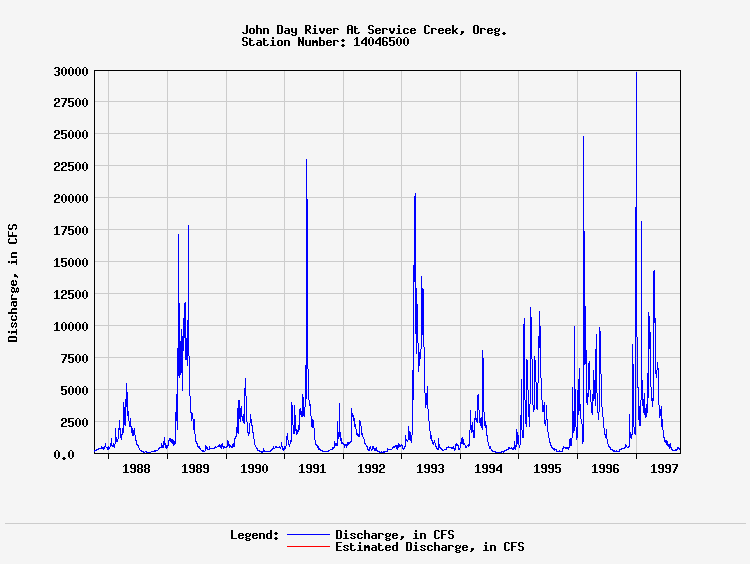
[2004-04-21]: Currently, long-term data have to be individually reqested from the USGS -
- in combination with the annual snow pack, long-term data can assist in planning late-season trips,
e.g. in the late 90s we used a 10-year period (
1987-1997 flow) to pick the 'perfect' time :-)
Books
Arthur Campbell, "John Day River -- Drift and Historic Guide
" ISBN 0-936608-11-0
John Garren, "Oregon River Tours" ISBN 0-941887-01-0
Pete Giordano and the Willamette Kayak and Canoe Club, "Soggy Sneakers", 4th Ed., Publ. The Mountaineers Books
(the Cottonwood to Columbia stretch was added in 2004 as run# 205)
Robb Keller, "Paddling Oregon" ISBN 1-56044-533-5
(hydrographs and gradient maps for each route)
BLM
Prineville District Office
Phone: (541) 416-6700
Contact the office for current boating and camping regulations, also ask
for maps and information regarding public/private land.
The office offers special maps for boaters with detailed information
about campsites along the river.
To go straight to
their John Day page
[Spring 2006: BLM is reworking their entire webpage -- specific John Day info may be spotty
or temporarily not available]
Corps of Engineers: John
Day Dam
Bob N. from the DKCC researched several options of accessing Tumwater
Falls by dirt road and/or by paddling the John Day upstream.
See his report and follow-up comments at the
DKCC Forum
[2004-04-21]
Different stretch: From South Fork to North Fork
In last week of May 2005, at ca. 800 cfs, Horst Lueck ran the John Day
from the South Fork (Dayville) to the confluence with the North Fork (Kimberly); class 2+ / 3
Report to be posted soon.
(
for preview see Trip Reports in Newsletter
)
Scott Reed did this run in late May 2006, at 5000 cfs.
General feedback: "Other than Tumwater, my experience matched your description very closely."
See his description of
Tumwater Falls at 5000 cfs
[2006-06-07]
Different stretch: Town of John Day to Town of Dayville
In first week of June 2006 Horst Lueck ran the John Day
from the town of John Day to the town of Dayville ; not yet rated.
Report to be posted soon.
This page:
http://canoe.freeshell.org/hbl_johnday_tumwater.shtml
Copyright - for non-commercial publications add
full reference to this Web page,
-
for commercial publications contact author
.